
MarineTraffic - what is it?
Marine traffic is a shareware service to track the location of a vessel online. On the world map you can find any ships that are in port or at sea. In the service options you can also track the location of the vessel by its name in real time.
When you select a vessel on the map, a window pops up with information about the vessel online:
- ship name
- type of vessel (container, tanker, passenger ship, etc.)
- ship status
- ship speed
- ship course
- ship's draft
Operating principle of Marine traffic and AIS systems
Nowadays, almost all ships are equipped with an automatic identification system, AIS, which allows you to track the ship and avoid collisions between ships. On what maximum distance can you track the ship on the map? It all depends on the height of the antenna located on the ship itself and at the nearest station on land. Conventional AIS stations cover a range of about 40 nautical miles (about 75 km). In some cases, the location of the ship can be tracked at a distance of 200 miles, and this is, not a little, 370 km. But this is the case if the AIS station is located high above sea level, for example on a mountain, and the ship itself is equipped with a good antenna. Thus, anyone can track a vessel online using the Marinetraffic service.
How to track a ship on the map?
If you have the name of a ship, the easiest way to find out the ship's location is to enter it in the map search and the system will immediately show the ship's position and information about it. If you know that the ship has not yet left a certain port or it could not have gone far from it, you can try to find the desired port in the same search form. And then use the familiar mouse actions to point at all the vessels and view information about them. Also, to make your search easier, you can filter ships by type. For example, select only passenger, fishing or cargo ships. The service is intuitive and if you have the skills to use a map, then finding out the location of the vessel in real time will not be difficult for you.
We present to you a unique map with which you can find the location of any ship in the world's oceans, as well as determine the direction of its movement.
The technology behind the card relies on a network of satellites capable of receiving encrypted Automatic Identification System, or AIS, signals. This system was developed specifically for civil navigation and is an encrypted signal transmitted by the ship into orbit. The signal contains basic information not only about the direction of movement of the vessel, but also key data about it - name, type, speed, cargo, destination port, etc. Information received by satellites is transmitted to the ground, where it is automatically processed.
The result of this processing was embodied in an interactive map of vessel movements, which can be seen below.
Interactive map of maritime traffic
Search for a ship by its name
A legend is attached to the map, thanks to which you can determine the type of ship being monitored. Similar data can be obtained by clicking on its icon on the map. You can monitor the movement of ships both in satellite mode and in the mode of overlaying a real image. In addition, if you know the name of the ship, you can find it on the map. To do this, you need to enter the name in the appropriate field on English language. If everything is done correctly, the map itself will be centered on the selected ship.
Video instructions for finding ships on the map
Map update
Almost all data shown on the map is updated in real time. It is worth remembering that the speed of movement of a ship on the open sea is relatively low, so if it seems that the ship is not moving, then perhaps you should just wait. However, the reason for the “freezing” of the ship may not be only this – the AIS satellite network still has “white spots” in the world’s oceans, into which ships periodically fall. In this case, you just need to wait until the ship can communicate with satellites again - its location will be updated.
AIS (AIS Automatic Identification System) is a system that allows you to identify and track online vessel movement with an accuracy of 10 meters. Besides AIS vessel locations provides information about their type, dimensions, destination, speed, expected time of arrival, and makes it possible to familiarize yourself with the history of routes and the expected course. The specified information is presented in a card, to open which you need to click on the object of interest. Online access to ships' AIS provided directly by ships using a radio frequency transmitter. Some ships or ports may not be viewable due to range limitations, interference, or weather conditions affecting radio communications. If " marine traffic” does not display the object you want, please try again later.
Real-time vessel traffic map covers the whole world and provides the user with the opportunity to see their arrangement in various ports and areas of the world. To find ships in other regions and ports, you need to zoom out on the map and select the desired sector.
The Answer-Logistic portal focuses on the current movement and positions of vessels according to AIS in the eastern part of the water area Gulf of Finland and the port of St. Petersburg. Note that ship deployment displayed with a slight delay. You can find out the time that has passed since the last coordinate update by hovering the cursor over an object.
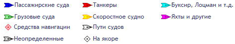
| Designations: | |
Thanks to the development of technology, modern society managed to fully develop ship transportation. Once upon a time, people traveled on wooden ships, guided by the stars, wasting a huge amount of time on the voyage. Then steamships appeared, speeding up these processes a little. However, now not only the vessels themselves have improved, but also the operational exchange of information.
Motor ships online in real time: what types of maps are there and how to use them
Today, an automatic identification system has been created that works thanks to radio waves broadcast using a transmitter and receiver. This is used to ensure that ships can follow a safe route and are always under surveillance. This system can be used not only by the management of shipping companies, but also by every person who wants to find out the location of the necessary vessel. The use of satellite map technology has made it possible to create special sea maps of motor ships in real time, which provide all the necessary information about active ports, ships and their course.
Passenger ship
Online maps of ships
So, there are many different services that offer their help in finding a ship. Typically these resources are presented in the form of a map on which all active civilian ships and their movements are indicated. Each such vehicle has its own unique code, which is broadcast and decrypted via satellites. Thanks to this, anyone can find out general information about the vessel: location, route, speed, type, cargo and even a photograph.
Important! Technology is not absolute. Information is updated in real time, of course, but there are many reasons for signal delays, for example, blind spots in certain places on the route. Therefore, the speed values, as well as the location of the ship, are likely to be inaccurate.
However, despite the fact that all sites have common goal- show the route of ships on the map in real time, they have different functions. For example, Scanmarine, which is located on the Russian segment, shows the territory schematically without the ability to select a satellite or another view; you can also only click on the markers to view the information, but you cannot find vessels by name. To get more options, you need to follow the link that can be seen on the map frame, or simply enter vesselfinder.com in the search engine.
On the Internet you can find many resources that use the same type of maps, for example, Google or Yandex. By going to the official page, you can use the search and get more accurate information.

Schematic map without relief
Passengers will have enough of these functions, but if other goals or more needs are a priority, then they will have to register, and on some sites, in order to get all the features, also buy premium access. It’s worth saying right away that one of the most popular now is Marinetraffic.com. This is due to its efficiency, convenience, simplicity and frequency of location updates.
How to use it?
When the site opens, you can immediately pay attention to the map, where there will be a huge number of markers of different colors, shapes and sizes. To figure this out, you need to look at the legend or additional footnotes, since different resources have different markings (in fact, there are about 3 maps themselves different types, which everyone uses by posting on their pages). Of course, in this chaos it will be very difficult to find the necessary vessel. Some sites offer a search that will immediately switch to the area where the required aircraft is located and its route along the route.

Found ship using search: satellite view
The map allows you to see the entire surface of the globe, which significantly increases the ability to track the ship. Everything is interactive - you need to hold down and move the mouse cursor in the required direction, so you can quickly move between different points of the planet. In addition, among other tools, zoom in, change of view (standard, simplified, satellite, hybrid), and in some even weather will be available. By the way, on original sites with maps, when registering, they ask for what purposes the resource will be used. The number of functions that will be available depends on this answer.
So, step by step instructions:
- You need to open the site and familiarize yourself with the map and legend.
- Register (required if you intend to use the “search” function).
- Click on the “magnifying glass” icon in the upper left corner, enter the exact name of the ship and wait until the map loads the area and route.
Note! Small boats are not subject to monitoring.
Is it worth contacting government services?
It is not always necessary to contact online maps to track your ship among thousands of others around the world. As an example, consider a river walk in your city. In this case, it is better to request a number from the port government service in advance in order to find out the schedule and negotiate tickets. This will be more practical than studying vehicle tracking. It is also not recommended to contact services via email, as waiting for a response may take a long time. It all depends on the case, since the request may wait in a queue or take a long time to process.
The AIS system has become very useful for all citizens different categories. For entrepreneurs or people who have entered into a contract, it is very important to track their cargo that is transported by a certain ship, as well as all other information about it.

Characteristics of the Carnival Fantasy ship
Thanks to radio signals, which are amplified by special positions with antennas, you can very accurately calculate the time and correctness of the route. Of course, for ordinary passengers such a system is very useful, universal and, in some cases, the only one. Having studied the method of action a little, you can easily find out all the answers to your questions.
Marine site Russia no October 15, 2016 Created: October 15, 2016 Updated: July 25, 2017 Views: 77110
Based on data from AIS. All vessel positions, departure from the port and arrival at the destination port in real time. Attention! The positions of the vessels may sometimes not correspond to the real ones and may lag behind by an hour or more. All coordinates of vessel positions are presented for informational purposes only.

Search data from AIS cannot be used for routing. When searching, you will find accurate information about the movements of ships on the map using AIS data and can view their photographs. In order to find a ship, select a sector on the map where the number of ships currently located there is indicated.
We click with the mouse, for example, on the region of Europe and get the picture that you see below. If you zoom in on the area, you will see specific vessels. The map receives updates every few seconds.
When you hover your cursor over a ship, you can see its name; on the site you can get other information you are interested in for searching. To find the ship you are interested in, enter the name of the ship and, if possible, its location in the search bar and press the search key. The AIS map will show the vessel's position in real time.
What is AIS?
 To reduce the risk of ship collisions, AIS - Automatic Identification System was developed in 2000. Its functionality turned out to be so successful that just two years later the International Maritime Organization demanded the mandatory installation of AIS terminals on all cargo ships with a displacement of more than 500 registered tons, on “trucks” over 300 tons on international voyages, and on all ships for passenger transport, regardless of tonnage
Unlike radars, which can detect the appearance of large floating objects near the ship and approximately estimate their current direction and speed of movement, AIS allows you to obtain much more detailed and accurate information about the navigation situation.
To better understand the possibilities new system, first let's figure out how it works.
The ship's AIS module is a digital VHF transceiver interfaced with ships' navigation systems. Depending on the speed of the vessel, every 2–10 seconds (every 3 minutes when stationary), it automatically transmits the following operational information: MMSI identification number, navigation status (“at anchor”, “underway”, etc.). ), current coordinates, true course and speed, angular rate of turn and exact time stamp.
![]() In addition to dynamic data, static data is transmitted every 6 minutes: the IMO vessel identification number, its type, name, radio call sign, dimensions, type of positioning system (GPS, GLONASS, LORAN) and even the position of its antenna relative to the bow of the vessel. Route information is transmitted at the same frequency: destination with estimated time of arrival, draft, cargo category and number of people on board. In addition, in the event of a threat to the safety of the vessel, it is allowed to send text messages entered manually from it.
In addition to dynamic data, static data is transmitted every 6 minutes: the IMO vessel identification number, its type, name, radio call sign, dimensions, type of positioning system (GPS, GLONASS, LORAN) and even the position of its antenna relative to the bow of the vessel. Route information is transmitted at the same frequency: destination with estimated time of arrival, draft, cargo category and number of people on board. In addition, in the event of a threat to the safety of the vessel, it is allowed to send text messages entered manually from it.
The received information can be displayed on the terminal in the form of a table with information about nearby vessels, as well as in the form of their symbols superimposed on navigation maps (for example, in a chartplotter) - of course, in this case it is much easier to assess the relative position and dynamics of movement.
![]() In short, according to AIS messages, the captain can absolutely accurately assess the current navigation situation. By the way, radio traffic in the system is carried out in the range of 162 MHz, that is, at a much lower frequency compared to radar radiation. Longer radio waves are able to bend around obstacles such as large ships and low islands, and therefore the AIS range is pleasantly impressive. Under favorable conditions, it can exceed 40 miles, but keep in mind that the height of the antenna here, as with other airborne transmitters, plays a decisive role.
In short, according to AIS messages, the captain can absolutely accurately assess the current navigation situation. By the way, radio traffic in the system is carried out in the range of 162 MHz, that is, at a much lower frequency compared to radar radiation. Longer radio waves are able to bend around obstacles such as large ships and low islands, and therefore the AIS range is pleasantly impressive. Under favorable conditions, it can exceed 40 miles, but keep in mind that the height of the antenna here, as with other airborne transmitters, plays a decisive role.
For yachtsmen, at least those whose vessels do not appear in the Forbes magazine charts, the subtlety of using the system lies in the fact that only simplified version terminals, designated “Class B”, are allowed to be installed on ships with a displacement of less than 300 tons.
![]() They feature a noticeably reduced transmitter power (2 W versus 12.5 W), which limits their transmission range to approximately five miles. Another nuisance is a simplified data transmission algorithm that allows you to send information only if there is free space on the air during the radio exchange of older brothers equipped with class A terminals. The trick here is that at any given time on any of the two AIS channels It is possible to transmit one single block of digital data, and Class A devices are able to agree with each other in advance about the order in which they are issued.
They feature a noticeably reduced transmitter power (2 W versus 12.5 W), which limits their transmission range to approximately five miles. Another nuisance is a simplified data transmission algorithm that allows you to send information only if there is free space on the air during the radio exchange of older brothers equipped with class A terminals. The trick here is that at any given time on any of the two AIS channels It is possible to transmit one single block of digital data, and Class A devices are able to agree with each other in advance about the order in which they are issued.
However, you must agree: despite such discrimination, being in a rough sea at night, it is very pleasant to know that on a supertanker passing nearby, the watchman probably knows about the presence of your 45-foot yacht at his side.
 There is another way to use AIS, and it involves installing a receiver that does not allow sending any data at all, but is capable of tracking the movements of all ships equipped with full-fledged terminals. By and large, you don't even need a separate device for this, since manufacturers like Icom and Standard Horizon have begun to equip high-end models of mounted VHF radios with this function.
Convenient, compact, not expensive, but there is one big “but” - it’s problematic to place even a text table on a small low-resolution screen, let alone build even the most primitive semblance of a map...
That is why AIS receivers were developed that do not display graphic information at all, but are able to convert data into packets of the standard NMEA protocol, which is understood by the vast majority of chartplotters. Plus, some of them can connect to computers via USB, or even transfer data via Wi-Fi to mobile gadgets running under Android control or iOS. Similar devices are produced, for example, by Weather Dock.
 By the way, when installing AIS equipment, even an additional antenna is not absolutely necessary due to operation in the same frequency range with the on-board radio. However, keep in mind that splitters used to connect two antennas different devices, as a rule, they slightly reduce the signal level, and in case of problems with a single antenna, you will lose two security systems at once.
It would be naive to believe that such an advanced information exchange system was created solely to assist helmsmen in operational maneuvering. The tasks of AIS also include global control monitoring the movements of vessels in the interests of various shipping companies, traffic control centers, as well as public services who may require information about the location of certain vessels or cargo. For this reason, AIS equipment can be based not only on ships, but also on coastal stations, many of which are connected to a global network.
 Well, in order to more effectively use the system to search and rescue sailors in emergency situations, emergency buoys are being produced that are capable of transmitting AIS information with high priority. There are also so-called virtual buoys - this is the only type of device in the system, whose real location may not coincide with the coordinates in their messages. As a rule, these are transmitters installed on the shore, warning passing ships of dangers such as poorly visible rocks or capes devoid of lighthouses jutting far out to sea.
It must be said that AIS receivers are even located on satellites. It is only on the surface of the Earth that the radius of propagation of its signal is limited by visibility to the horizon, but in space it can be received from hundreds of kilometers without any problems. Today more than a dozen orbit around the planet spacecraft engaged in monitoring maritime traffic.
 It’s especially nice that you can get to data on the global movement of ships without being the owner of a shipping company or a secret service agent. Information is available on a paid basis (for example, in full version Google Earth), however, in a somewhat truncated form, it can be seen for free, for example, on the resource www.marinetraffic.com, whose interactive maps and user-friendly interface are replicated on many other nautical websites.